BRINDLEFORD WEATHER DESK
09.27 / DEMO SCENARIO
Brindleford storm watch
Warnings, forecasts and local updates as conditions change.
Brindleford
18°

Heavy rain
H: 20° L: 15°
Now

18°
16:00
18°
17:00

17°
18:00
17°
19:00
16°
20:00

16°
Live
ROAD CLOSURE
River Road closed near Eastbank
Floodwater has reached the road between the station and the old bridge. Transport officials confirm the closure and a diversion for traffic and buses.
Source: Brindleford Transport Department · 15:08
Riley Hart · Reporter · Eastbank
FORECAST UPDATE
Another band of rain is on the way
After a brief easing, rainfall is expected to intensify again. The next band reaches Brindleford this evening, with the heaviest period between 17:00 and 19:00.
- Forecast rain
- 40–60 mm
- Next 3 hours · 15:00–18:00
- Peak rainfall window
- 17:00–19:00
- This evening · Local time
Rain expected each hour - 10 mm
15:00
- 14 mm
16:00
- 22 mm
17:00
- 20 mm
18:00
- 13 mm
19:00
- 7 mm
20:00
Forecast rainfall · mm per hour · Issued 15:00
Source: Brindleford Weather Service · Forecast 15:00
Morgan Ellis · Weather editor · Forecast desk
WARNING ISSUED
Amber rain warning for three districts
AMBER / HEAVY RAIN
ACTIVE WARNING
Valid today, 15:00–21:00 · Issued at 14:30
Eastbank, Riverside and Northfield are covered until 21:00. Surface flooding and travel disruption are possible; avoid flooded roads and follow local notices.
Where the warning appliesUpdated 14:30 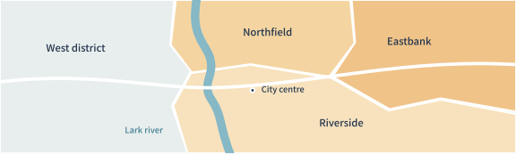
Warning area
Illustrative map · Not for navigation
Source: Brindleford Weather Service · Bulletin 027
Morgan Ellis · Weather editor · Forecast desk